
MUDARRAJ STATION
GPS: 25.687805, 38.695658
25°41'16.09"N 38°41'44.37"E
Distance to next station south (Hedia): 17 km
Distance to next station north (Wayban): 22 km
Altitude: 445 m

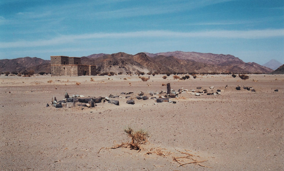
Two-storey black basalt stone station building, edged in red sandstone.
TE Lawrence calls it 'Madahrij Station'
Remains of a wagon to the north (now disappeared).
Two birkas by the south wall of the station.
Small collection of stone structures, including the remains of a clay oven to the north-west of the station.
Graves on the eastern side of the station.
Double-track crossing point in front of the station.
April 1917 - Site of Lawrence’s second raid 4.5 kms south of the station (see details below).
July 1917 - Site of a raid on the line by Lt. Col. Joyce at the same location.
Piles of stones at intervals along the side of the track were originally used as protection around the base of the telegraph poles.

Mudarraj Station was constructed from black basalt stone, trimmed with red sandstone blocks sourced from the surrounding hills

Mudarraj Station from the air. The station had two small birkas (water reservoirs) to the south of the main building and a double-track crossing point to the east

Closer view of the two birkas (water reservoirs) by the southern wall of Mudarraj Station. These reservoirs were filled by special trains which delivered to stations without natural water sources

Looking northwards from Mudarraj Station as the line winds its way through mountain valleys in the direction of Wayban and beyond to the major stations of AlUla and Hegra (Medain Saleh)

Looking southwards from the roof of Mudarraj Station in the direction of Hedia. TE Lawrence's second attack on the line took place at Km 1121 (measured from Damascus), 4.5 kms south of the station building
Following his attack on Abu Na'am Station, Lawrence continued southwards up the line in April 1917 towards Mudarraj Station (he calls it Madahrij), 17 kilometres north of Hedia. The raiding party comprised 40 Juhanni tribesmen and a machine-gun crew of 13. Approaching the railway through rain and a bitter wind, the party could hear the food-call of Turkish bugles at Mudarraj Station, below which they intended to carry out their raid. 'So we steered on the hateful noise, hateful because it spoke of supper and of tents, whereas we were shelterless, and on such a night could not hope to make ourselves a fire and bake bread from the flour and water in our saddle-bags, and consequently must go hungry'.

As Lawrence approached the railway through rain and a bitter wind, he enviously smelled the station garrison's dinner being freshly roasted in their open clay oven, the remains of which can still be seen today
The raiding party reached the railway on 5 April and Lawrence laid a mine at kilometre 1121, four and a half kilometres south of Mudarraj Station. It took him several hours, but by dawn the party was safely secluded on some low hills overlooking the wide valley through which the line ran. In the early morning, a patrol on a trolley passed over the mine without detonating it and a force came down the line from Mudarraj to repair telegraph poles. At 7.30 a.m. another patrol of eleven men came down the tracks to inspect the rails. Seeing footprints in the sand, they halted and carried out a thorough search, but Lawrence's mine was well hidden and eventually they continued south.

Mudarraj Station from the east
A line of graves to the east of Mudarraj Station bears witness to the hardships of everyday life for the garrisons of the Hejaz Railway as well as the wartime toll of defending the station against Bedouin attack
Shortly afterwards a train full of refugee women and children from Medina passed over the mine without detonating it. Lawrence wrote: ’As artist I was furious; as commander deeply relieved: women and children were not proper spoil.' As the train rolled over the mine, a number of the raiding party, expecting it to explode, rushed out into the open, giving away their hill-top hiding place to the Turkish defenders. From the direction of Mudarraj Station there now came a heavy barrage of rifle fire, harmless because the tribesmen were well out of range. Hedia Station was alerted by telegraph, and this was a more serious threat, for there were over a thousand men garrisoned at the station, well-positioned to block a retreat down Wadi Hamdh.

Commanding view from Lawrence's hilltop vantage point, looking south towards Hedia.. The long 27-arch bridge and station depot are on the other side of the highest mountain
When darkness fell, Lawrence returned with the tribesmen and re-set the defective mine. The party then blew up a small four-arch bridge, destroyed about 200 rails and demolished a long stretch of the telegraph. Worried that their retreat would be cut off, they quickly rode to safety through Wadi Hamdh. The following morning as they sat at the oasis of Bir Rubiaan, they felt the distant shock of a great explosion. Two scouts left behind at the railway arrived to tell them that a train carrying a labour gang and spare rails for the bridge had set off the mine.